
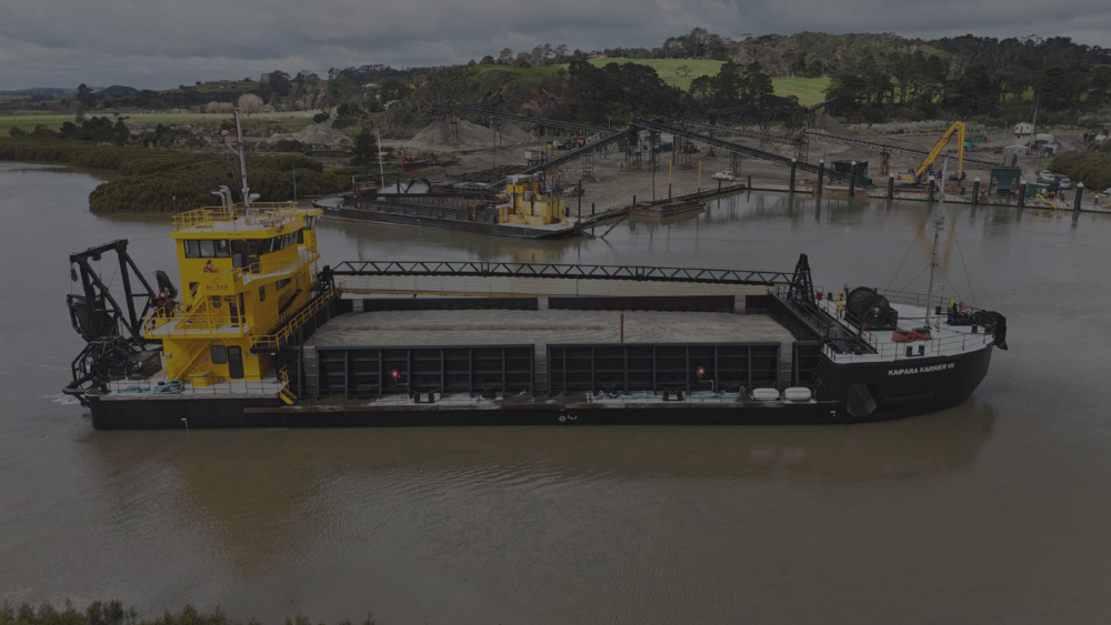
The Proposal
Winstone Aggregates and Mt Rex Shipping are seeking to renew their existing resource consents for sand extraction in the Kaipara Harbour. The proposal for each consent is for the same rate and volume of extraction currently authorised, supported by long-term monitoring undertaken by NIWA. Being:
- An extraction rate of 308,000 cubic metres per annum for Winstone Aggregates, and
- An extraction rate of 392,000 cubic metres per annum for Mt Rex Shipping.
The current consents expire on 4 September 2026 and the project team is working towards lodgement well in advance of the expiry of the consents, with lodgement planned for the end of November 2025.
Renewal Proposal
- Renew existing consents for the same extraction rate and area (with the exclusion zone).
- To continue supplying sand for regional construction needs.
- To maintain existing operational practices that have been shown through monitoring to have no significant adverse environmental effects.
- To align the extraction area with the self-imposed exclusion zone around Manukapua Island.
- Retain the Kaipara Harbour Sand Extraction Monitoring Group to oversee monitoring.
Key Features of the renewal consents
- No increase in extraction rate or area.
- No change to method of extraction.
- Maintain proven, well-managed extraction practices.
- The monitoring records complied under the existing consents demonstrate that the sand extraction activities have not been impacting on the receiving environment. It is proposed to continue the monitoring and reporting based on the recommendations of NIWA as the current monitoring and reporting regime is providing a reliable record of the consent activities. This current regime supports the scientific review and reporting required to demonstrate that the effects of the sand extraction are appropriate within the receiving environment.
- Ongoing engagement with Mana Whenua, the community, and Council through the Kaipara Harbour Sand Extraction Monitoring Group (KHSEMG).
Location
- The extraction area is within the Kaipara Harbour, seaward of Tapora and Manukapua Island.
- Activities occur entirely within the Coastal Marine Area.
- A self-imposed exclusion zone has been established around Manukapua Island (Site of Significance to Mana Whenua – Site ID-0192). See area in black below.


Monitoring
Ongoing Monitoring
Monitoring is undertaken by NIWA and includes both biological and coastal components:
- Biological Monitoring
- Surveys at 16 sites (8 within the extraction area and 8 control sites).
- Sampling and expert analysis every 6 years.
- Coastal Monitoring
- Annual aerial photogrammetry of Manukapua Island, South Head, and Pouto Point.
- Bathymetric surveys every two years.
- Digital terrain models comparing coastal shape and elevation changes over time.
Reporting
- Results are independently assessed by NIWA.
- Annual reports are reported to the Council and presented to the Kaipara Harbour Sand Extraction Monitoring Group (KHSEMG), which includes Mana Whenua and community representatives.
- Monitoring to date shows no significant impact on the receiving environment.
It is proposed to seek consent on the basis that the current monitoring and reporting regime will be continued.
Consenting Requirements:
It is anticipated that consents will be required for both the extraction of sand, and for the monitoring of the consent. No consents are required for the associated land-based activities.
Auckland Unitary Plan:
Extraction of Sand:
The extraction of sand from the Kaipara Harbour is located exclusively within the General Coastal Marine Zone, and it is expected to require a coastal permit (s12) and a discharge permit (s15) for the following reasons:
Coastal Permit (s12)
F2 Coastal – General Coastal Marine Zone
- Coastal marine disturbance for mineral extraction (excluding petroleum) requires consent as a discretionary activity within the General Coastal Marine Zone in accordance with rule F2.19.4 (A28).
Discharge Permit (s15)
F2 Coastal – General Coastal Marine Zone
- The disposal or storage of waste or other matter arising directly from, or related to, the exploitation and associated offshore processing of seabed mineral resources within the General Coastal Marine Zone requires consent as a discretionary in accordance with rule F2.19.2 (A15).
Note:
No specific consents relating to the extraction of sand are expected to be required with respect to the following Chapters of the AUP (OP):
- Chapter D9 Significant Ecological Areas Overlay (Rules are contained within F2 and covered above)
- Chapter D10 Outstanding Natural Features Overlay and Outstanding Natural Landscapes Overlay
- Chapter D21 Sites of Significance to Mana Whenua (as amended by Plan Change 102), or with respect to the various overlays
- Chapter D11 Outstanding Natural Character and High Natural Character Overlay
Consents required for Monitoring
It is proposed to continue monitoring in line with the existing consents (as amended in 2013). Monitoring is therefore proposed at Tapora Banks, Taporapora Island, and South Head, which is subject to the following overlays:
- Natural Resources: Significant Ecological Areas Overlay – SEA-M1-2w2, Significant wading bird area, Marine 1
- Natural Resources: Significant Ecological Areas Overlay – SEA-M1-2g, Marine 1
- Natural Resources: Significant Ecological Areas Overlay – SEA-M1-2a, Marine 1
- Natural Resources: Significant Ecological Areas Overlay – SEA_T_6748, Terrestrial
- Natural Heritage: Outstanding Natural Features Overlay [rcp/dp]
– ID 88, Manukapua Island (Big Sand Island)
- Natural Heritage: Outstanding Natural Features Overlay [rcp/dp]
– ID 205, Tapora dunes
- Natural Heritage: Outstanding Natural Landscapes Overlay [rcp/dp]
– Area 20, Tapora Dune islands and CMA
- Natural Heritage: Outstanding Natural Character Overlay [rcp/dp]
– AREA 1, Manukapua Island & Tapora Bank
- Natural Heritage: High Natural Character Overlay [rcp/dp]
– AREA 2, Tapora Bank
As such, it is expected that a coastal permit (s12) will be required for the following reasons:
Coastal Permit (s12)
F2 Coastal – General Coastal Marine Zone
- Within the Coastal marine area, disturbance related to scientific or engineering investigations, including taking samples within the following overlays requires consent in accordance with F2.19.4 (A25):
- SEA-M1 Overlay – Discretionary Activity
- ONL – Discretionary Activity
- ONF – Discretionary Activity
Relevant overlays (SEA / ONL / ONF / ONC) – Source Auckland Council GIS

Northland Regional Plan:
All extraction activities occur within the Auckland Council Region, and no consents are required under the Northland Regional Plan for the activity.
Monitoring of the consent is proposed to continue at Pouto. It is anticipated that this monitoring will be able to be undertaken in accordance with the permitted activity C.1.5.3 Sampling and scientific investigation.